Isaias strengthened into a Category 2 hurricane overnight and sat about 230 miles south of the mouth of the Mississippi River early Friday, the National Hurricane Center said.
By the numbers: Maximum sustained winds reached 105 mph at 1 am CDT Friday, with a minimum central pressure of 972 millibars, as the storm moved north-northeast at 14 mph.
- Both NOAA and Air Force hurricane hunter aircraft were flying inside Isaias when the advisory went out.
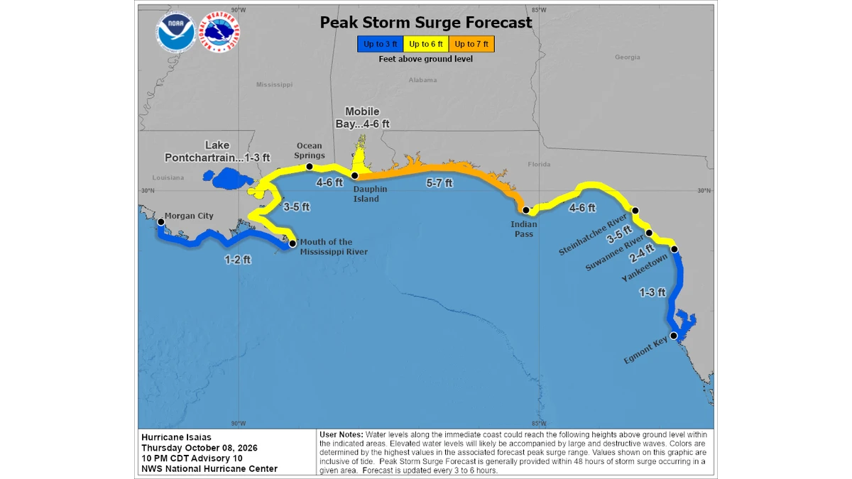
Zoom in: A hurricane warning covers Ocean Springs, Mississippi to the Bay and Gulf county line in Florida, and a storm surge warning runs from the mouth of the Mississippi River east to the Suwannee River.
- Peak surge forecasts reach 5 to 7 feet between Dauphin Island and Indian Pass, 4 to 6 feet in Mobile Bay, and 1 to 3 feet around Lake Pontchartrain.
- A tropical storm warning also covers the Louisiana coast from the Jefferson and Plaquemines parish line, and the Florida coast east to the Aucilla River.
What's next: The forecast track carries Isaias ashore Friday night and weakens it over Alabama through Saturday, fading to a post-tropical low as it tracks inland early next week.
Yes, but: Watches and warnings were unchanged with this advisory, and a storm surge watch remains in effect from the Suwannee River south to Yankeetown, Florida.
The big picture: The hurricane center called the surge a life threatening situation and told people in the warning area to follow evacuation instructions from local officials promptly.
Why it matters: A hurricane warning means hurricane conditions are expected somewhere in the area within 24 hours, and the center said preparations to protect life and property should be rushed to completion.