Isaias strengthened into a hurricane late Wednesday with 75 mph winds, the first of the 2026 Atlantic season and the latest a first hurricane has formed in 121 years.
By the numbers: Isaias crossed the hurricane threshold on October 7, just missing a record for the latest first Atlantic hurricane set on October 8, 1905, per NOAA data. Early Thursday it carried 75 mph sustained winds and a central pressure of 981 millibars measured by a hurricane hunter dropsonde.
- Hurricane-force winds reach only 25 miles from the center, while tropical-storm-force winds extend 60 miles out from it.
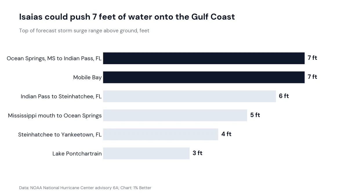
Zoom in: A hurricane warning runs from Ocean Springs, Mississippi across Alabama to Florida's Bay and Gulf county line, with a storm surge warning from the mouth of the Mississippi River to the Steinhatchee River. Forecasters put the peak surge at 5 to 7 feet along that coast and inside Mobile Bay.
What's next: Isaias passes north of the Yucatan Peninsula later Thursday, then turns northeast and north, with landfall inside the warning area late Friday or early Saturday. The hurricane center expects more strengthening through early Friday.
- Florida Governor Ron DeSantis declared a state of emergency for more than two dozen counties, and Alabama Governor Kay Ivey did the same for 40.
Between the lines: Rain is the wider threat. The hurricane center forecasts 3 to 7 inches along the coast from southeastern Louisiana to the Florida panhandle, with up to 10 inches in spots and heavy rain reaching the Tennessee Valley and the Carolinas.
Why it matters: A storm surge warning means life-threatening inundation is possible within 36 hours, and the National Weather Service tells anyone inside the zone to follow local evacuation orders promptly. The hurricane center warned that a life-threatening storm surge is expected as Isaias approaches on Friday.